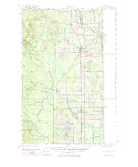
1951 Map of Bridgewater
USGS Topo · Published 1965About this map
Monticello and Bridgewater anchor this mid-century portrait of Aroostook County, where the agricultural and timber economy is defined by the Bangor and Aroostook railroad line and the international border. The survey details a landscape of managed woodlots and ridges, including Brooks Ridge and Wellington Ridge, divided into traditional townships and the Cox Patent. The border with Canada is punctuated by U S Customs stations, reflecting the importance of cross-border transit along the U S Customs Road. Rural life is centered around local institutions like Flagstaff Sch and the Lake Sch, while small clusters like Snow Settlement and Robinsons show the dispersed nature of the northern Maine woods. The Meduxnekeag River and its numerous branches, such as North Branch Three Brook, serve as the primary drainage for the countless ponds and lakes dotting the terrain.
Find a feature on this map
100 named features on this map. Tap any name to fly to it.
Don’t see what you’re looking for? This feature index may not catch every label — zoom into the map to look around manually.
Map Details
Editions of this 1951 Bridgewater Map
3 editions found

Other maps of this area

1934 · Bridgewater
USGS Topo · 1:48,000

1935 · Howe Brook
USGS Topo · 1:48,000

1935 · Presque Isle
USGS Topo · 1:62,500

1936 · Mars Hill
USGS Topo · 1:48,000

1937 · Smyrna Mills
USGS Topo · 1:62,500

1938 · Bridgewater
USGS Topo · 1:62,500

1938 · Houlton
USGS Topo · 1:62,500

1939 · Howe Brook
USGS Topo · 1:62,500

1940 · Mars Hill
USGS Topo · 1:62,500

1951 · Mars Hill
USGS Topo · 1:62,500