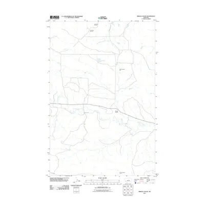
2011 Map of Briggs Coulee
USGS Topo · Published 2011About this map
McDonald Creek meanders through this Fergus County landscape, defining the local drainage and topography in a region marked by rural water management. The presence of multiple impoundments, such as Lewis Brothers Dam, Lewis Dam Number 1, and Lewis Dam Number 2, suggests a landscape oriented toward ranching and livestock support. These small-scale dams and reservoirs are clustered in the northern and central sections, indicative of the vital role water conservation plays in this part of Montana. Named geographic features like Briggs Coulee provide further insight into the land's relief. The transport network is comprised of utilitarian ranch and service routes, including Stark Ranch Rd and Gravel Pit Rd, which provide access to the area's resources and isolated homesteads. Near the southern boundary, the Archer Number 2 Dam serves as another localized landmark in this sparsely settled prairie environment.
Find a feature on this map
10 named features on this map. Tap any name to fly to it.
Don’t see what you’re looking for? This feature index may not catch every label — zoom into the map to look around manually.
Map Details
Editions of this 2011 Briggs Coulee Map
This is the sole edition of this map. No revisions or reprints were ever made.
Other maps of this area

1954 · Roundup
USGS Topo · 1:250,000

1954 · Lewistown
USGS Topo · 1:250,000

1958 · Roundup
USGS Topo · 1:250,000

1959 · Lewistown
USGS Topo · 1:250,000

1986 · Snoose Creek
USGS Topo · 1:24,000

1986 · Wild Horse Lake
USGS Topo · 1:24,000

1986 · Briggs Coulee
USGS Topo · 1:24,000
1986 · Grass Range
USGS Topo · 1:24,000

1986 · Teigen NW
USGS Topo · 1:24,000
1986 · Grass Range NE
USGS Topo · 1:24,000