1986 Map of Teigen NW
USGS Topo · Published 1986About this map
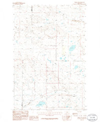
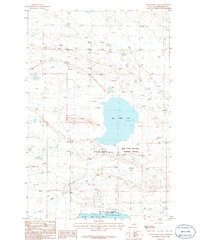
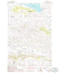
Three Buttes dominates the southwestern corner of this mid-1980s provisional survey, which documents the remote drainage systems along the border of Fergus and Petroleum counties. The landscape is defined by its seasonal hydrology, where the South Fork Bear Creek and Duck Creek carve subtle paths through the high plains. The drainage network is particularly dense in the south, where Fords Creek, Brickyard Creek, and Three Buttes Creek converge. These waterways provided the essential infrastructure for ranching and homesteading in a region where water availability dictated the placement of every fence line and stock tank. The map captures this part of Central Montana just as modern digital mapping techniques began to replace traditional manuscript drawings, preserving the traditional nomenclature of local landmarks and intermittent streams.
Find a feature on this map
7 named features on this map. Tap any name to fly to it.
Don’t see what you’re looking for? This feature index may not catch every label — zoom into the map to look around manually.
Map Details
Editions of this 1986 Teigen NW Map
This is the sole edition of this map. No revisions or reprints were ever made.
Other maps of this area

1954 · Lewistown
USGS Topo · 1:250,000

1959 · Lewistown
USGS Topo · 1:250,000
1985 · Bear Creek Reservoir SE
USGS Topo · 1:24,000
1985 · Bear Creek Reservoir
USGS Topo · 1:24,000
1985 · Bohemian Corners
USGS Topo · 1:24,000
1986 · Wild Horse Lake
USGS Topo · 1:24,000
1986 · Briggs Coulee
USGS Topo · 1:24,000
1986 · Grass Range
USGS Topo · 1:24,000
1986 · Grass Range NE
USGS Topo · 1:24,000
1986 · Teigen
USGS Topo · 1:24,000