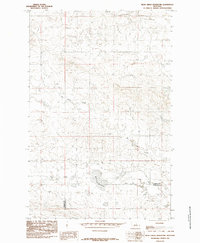
1985 Map of Bear Creek Reservoir
USGS Topo · Published 1985About this map
Bear Creek Reservoir serves as a central landmark in this high-plains landscape where the border between Fergus and Petroleum counties meets. The terrain is defined by the winding paths of Box Elder Creek and Antelope Creek, which carve through the Montana rangeland. This 1985 provisional edition, compiled from 1970s aerial photography, captures a sparsely populated region primarily characterized by its drainage systems and the local water infrastructure necessary for the area. The map highlights the transition of Bear Creek as it flows toward the reservoir, providing a clear look at the hydrological layout of this central Montana borderland during the mid-1980s.
Find a feature on this map
5 named features on this map. Tap any name to fly to it.
Don’t see what you’re looking for? This feature index may not catch every label — zoom into the map to look around manually.
Map Details
Editions of this 1985 Bear Creek Reservoir Map
This is the sole edition of this map. No revisions or reprints were ever made.
Other maps of this area

1954 · Lewistown
USGS Topo · 1:250,000

1959 · Lewistown
USGS Topo · 1:250,000

1985 · Griffee Coulee
USGS Topo · 1:24,000

1985 · Bear Creek Reservoir SE
USGS Topo · 1:24,000

1985 · Sloan Reservoir
USGS Topo · 1:24,000
1985 · Kachia Reservoir
USGS Topo · 1:24,000
1985 · Bohemian Corners
USGS Topo · 1:24,000

1986 · Wild Horse Lake
USGS Topo · 1:24,000

1986 · Teigen NW
USGS Topo · 1:24,000
1986 · Grass Range NE
USGS Topo · 1:24,000