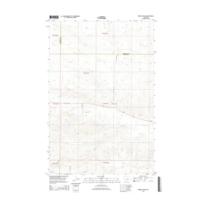
2014 Map of Briggs Coulee
USGS Topo · Published 2014About this map
Briggs Coulee defines the drainage patterns of this Central Montana landscape, where the boundary between Fergus and Petroleum counties cuts through high plains and sharp breaks. The meandering path of McDonald Cr provides the primary water source for the region, influencing the local layout of rural routes and property divisions. Modern infrastructure is represented by the traverse of Mt-200, which serves as a vital corridor through these sparsely populated ranch lands.
Find a feature on this map
17 named features on this map. Tap any name to fly to it.
Don’t see what you’re looking for? This feature index may not catch every label — zoom into the map to look around manually.
Map Details
Editions of this 2014 Briggs Coulee Map
This is the sole edition of this map. No revisions or reprints were ever made.
Other maps of this area

1954 · Roundup
USGS Topo · 1:250,000

1954 · Lewistown
USGS Topo · 1:250,000

1958 · Roundup
USGS Topo · 1:250,000

1959 · Lewistown
USGS Topo · 1:250,000

1986 · Snoose Creek
USGS Topo · 1:24,000

1986 · Wild Horse Lake
USGS Topo · 1:24,000

1986 · Briggs Coulee
USGS Topo · 1:24,000
1986 · Grass Range
USGS Topo · 1:24,000

1986 · Teigen NW
USGS Topo · 1:24,000
1986 · Grass Range NE
USGS Topo · 1:24,000