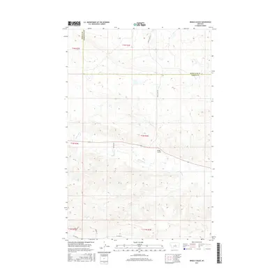
2017 Map of Briggs Coulee
USGS Topo · Published 2017About this map
Briggs Coulee carves through this central Montana landscape, where the boundary between Fergus and Petroleum Counties runs along the northern section. The terrain is defined by the winding course of McDonald Cr, which flows through several townships including t15n r24e and t15n r23e. This area reflects a traditional Western ranching layout, with long-established property lines and access routes following the natural drainage of the land.
Find a feature on this map
14 named features on this map. Tap any name to fly to it.
Don’t see what you’re looking for? This feature index may not catch every label — zoom into the map to look around manually.
Map Details
Editions of this 2017 Briggs Coulee Map
This is the sole edition of this map. No revisions or reprints were ever made.
Other maps of this area

1954 · Roundup
USGS Topo · 1:250,000

1954 · Lewistown
USGS Topo · 1:250,000

1958 · Roundup
USGS Topo · 1:250,000

1959 · Lewistown
USGS Topo · 1:250,000

1986 · Snoose Creek
USGS Topo · 1:24,000

1986 · Wild Horse Lake
USGS Topo · 1:24,000

1986 · Briggs Coulee
USGS Topo · 1:24,000
1986 · Grass Range
USGS Topo · 1:24,000

1986 · Teigen NW
USGS Topo · 1:24,000
1986 · Grass Range NE
USGS Topo · 1:24,000