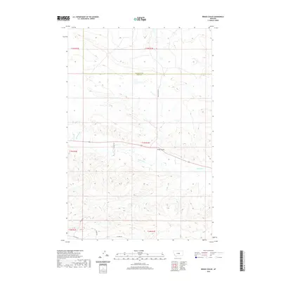
2020 Map of Briggs Coulee
USGS Topo · Published 2020About this map
McDonald Cr meanders through this section of Central Montana, cutting through a landscape of deep coulees and draws. The terrain is defined by the prominent Briggs Coulee, which serves as a natural corridor for the rural transportation network. The 2020 map documents the border between Petroleum and Fergus counties, illustrating how modern land divisions still respect the natural topography and the Public Land Survey System. A sparse network of gravel routes and trails, including Matovich Rd and Penhour Rd, provides access to this isolated ranching country. The presence of Yonder Trl and Elk Creek Rd suggests the enduring reliance on local access roads to navigate the complex drainage patterns established by the creek and its many unnamed tributaries.
Find a feature on this map
14 named features on this map. Tap any name to fly to it.
Don’t see what you’re looking for? This feature index may not catch every label — zoom into the map to look around manually.
Map Details
Editions of this 2020 Briggs Coulee Map
This is the sole edition of this map. No revisions or reprints were ever made.
Other maps of this area

1954 · Roundup
USGS Topo · 1:250,000

1954 · Lewistown
USGS Topo · 1:250,000

1958 · Roundup
USGS Topo · 1:250,000

1959 · Lewistown
USGS Topo · 1:250,000

1986 · Snoose Creek
USGS Topo · 1:24,000

1986 · Wild Horse Lake
USGS Topo · 1:24,000

1986 · Briggs Coulee
USGS Topo · 1:24,000
1986 · Grass Range
USGS Topo · 1:24,000

1986 · Teigen NW
USGS Topo · 1:24,000
1986 · Grass Range NE
USGS Topo · 1:24,000