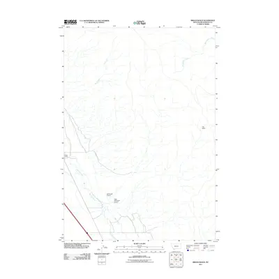
2011 Map of Briggs Ranch
USGS Topo · Published 2011About this map
Briggs Ranch sits along the western edge of this Beaverhead County landscape, where the Red Rock River winds through the valley floor. The terrain is defined by a series of drainages and canyons that cut through the high country, most notably Ashbough Canyon and Little Ashbough Canyon to the south. Transportation in this high-elevation grazing and watershed area is limited to rugged tracks like the Ashbough Trl, which provides access through the southern breaks. To the north and east, the map traces the headwaters of numerous streams including Buck Creek and Burnt Willow Creek, illustrating a classic intermountain drainage pattern. A large topographical depression known as The Basin occupies the eastern portion of the sheet, while Sage Creek flows toward the river valley, marking the transition from the upland slopes to the alluvial bottomlands.
Find a feature on this map
9 named features on this map. Tap any name to fly to it.
Don’t see what you’re looking for? This feature index may not catch every label — zoom into the map to look around manually.
Map Details
Editions of this 2011 Briggs Ranch Map
This is the sole edition of this map. No revisions or reprints were ever made.
Other maps of this area

1955 · Dubois
USGS Topo · 1:250,000

1958 · Dubois
USGS Topo · 1:250,000

1965 · Kidd
USGS Topo · 1:24,000
1965 · Monument Hill
USGS Topo · 1:24,000

1965 · Lima
USGS Topo · 1:24,000

1965 · Briggs Ranch
USGS Topo · 1:24,000
1965 · Red Rock
USGS Topo · 1:24,000

1965 · Rock Island Ranch
USGS Topo · 1:24,000
1965 · Beech Creek
USGS Topo · 1:24,000

1965 · Dixon Mountain
USGS Topo · 1:24,000