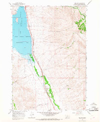
1965 Map of Red Rock
USGS Topo · Published 1968About this map
The Clark Canyon Reservoir dominates the northwestern portion of this landscape, its waters held back by the Clark Canyon Dam. This mid-1960s survey illustrates a rural corridor where the Union Pacific railroad tracks parallel the Red Rock River, connecting the small settlement of Red Rock to the surrounding ranching and mining lands. The topography is defined by numerous drainage systems cutting through the high ground, including Limekiln Canyon and Bell Canyon, which feed into the central valley.
Find a feature on this map
21 named features on this map. Tap any name to fly to it.
Don’t see what you’re looking for? This feature index may not catch every label — zoom into the map to look around manually.
Map Details
Editions of this 1965 Red Rock Map
2 editions found
Other maps of this area

1893 · Dillon
USGS Topo · 1:250,000

1952 · Eli Spring
USGS Topo · 1:24,000

1952 · Dalys
USGS Topo · 1:24,000

1952 · Gallagher Mountain
USGS Topo · 1:24,000

1955 · Dubois
USGS Topo · 1:250,000

1955 · Dillon
USGS Topo · 1:250,000

1957 · Dillon
USGS Topo · 1:250,000

1958 · Dubois
USGS Topo · 1:250,000

1958 · Dillon
USGS Topo · 1:250,000

1962 · Dillon
USGS Topo · 1:250,000