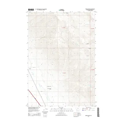
2014 Map of Briggs Ranch
USGS Topo · Published 2014About this map
Briggs Ranch serves as a lone settlement marker in this high-elevation landscape of Beaverhead County, where the topography is defined by the winding course of the Red Rock River. The map documents a network of canyons and gulches, including Ashbough Canyon and Little Ashbough Canyon, which drain into the river valley. Local access is marked by specific named routes like Ashbough Trl, Wolfe Ln, and Bimat Ln, providing a detailed look at the ranching infrastructure and land divisions in this part of Montana during the early 21st century. The drainage patterns are intricate, featuring several seasonal or small-scale water sources such as Sage Cr, Burnt-Willow Cr, and Knox Spring. A unique depression known as The Basin sits nestled among the ridges near Big Spring Gulch, illustrating the complex geological features of the region.
Find a feature on this map
21 named features on this map. Tap any name to fly to it.
Don’t see what you’re looking for? This feature index may not catch every label — zoom into the map to look around manually.
Map Details
Editions of this 2014 Briggs Ranch Map
This is the sole edition of this map. No revisions or reprints were ever made.
Other maps of this area

1955 · Dubois
USGS Topo · 1:250,000

1958 · Dubois
USGS Topo · 1:250,000

1965 · Kidd
USGS Topo · 1:24,000
1965 · Monument Hill
USGS Topo · 1:24,000

1965 · Lima
USGS Topo · 1:24,000

1965 · Briggs Ranch
USGS Topo · 1:24,000
1965 · Red Rock
USGS Topo · 1:24,000

1965 · Rock Island Ranch
USGS Topo · 1:24,000
1965 · Beech Creek
USGS Topo · 1:24,000

1965 · Dixon Mountain
USGS Topo · 1:24,000