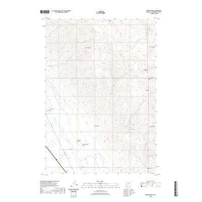
2020 Map of Briggs Ranch
USGS Topo · Published 2020About this map
Briggs Ranch serves as a primary landmark in this corner of Beaverhead County, where the valley floor meets the high-elevation drainage systems of the southwestern Montana mountains. The Red Rock River defines the western lowlands, accompanied by Red Rock Rd and Wolf Ln, while the eastern portion of the map is dominated by a complex network of canyons and gulches. Significant topographic features like Ashbough Canyon, Little Ashbough Canyon, and The Basin illustrate the dramatic vertical rise of the terrain. Water sources are vital in this arid ranching landscape, as evidenced by the presence of Ashbough Spring, Knox Spring, and the perennial flows of Buck Cr and Burnt Willow Cr. This survey captures the specialized infrastructure of public land management and high-country ranching, including the primitive Ashbough Trl and various Bureau of Land Management routes.
Find a feature on this map
26 named features on this map. Tap any name to fly to it.
Don’t see what you’re looking for? This feature index may not catch every label — zoom into the map to look around manually.
Map Details
Editions of this 2020 Briggs Ranch Map
This is the sole edition of this map. No revisions or reprints were ever made.
Other maps of this area

1955 · Dubois
USGS Topo · 1:250,000

1958 · Dubois
USGS Topo · 1:250,000

1965 · Kidd
USGS Topo · 1:24,000
1965 · Monument Hill
USGS Topo · 1:24,000

1965 · Lima
USGS Topo · 1:24,000

1965 · Briggs Ranch
USGS Topo · 1:24,000
1965 · Red Rock
USGS Topo · 1:24,000

1965 · Rock Island Ranch
USGS Topo · 1:24,000
1965 · Beech Creek
USGS Topo · 1:24,000

1965 · Dixon Mountain
USGS Topo · 1:24,000