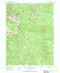
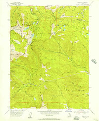
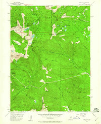
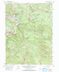
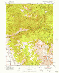
1955 Map of Brighton
USGS Topo · Published 1970About this map
The high Wasatch Range terrain around Brighton is defined by a dense concentration of early silver and lead mining operations, reflected in a landscape riddled with shafts and tunnels. Extensive underground workings like the Michigan-Utah Mine, Flagstaff Mine, and Prince of Wales Shaft occupy the peaks and ridges, while long subterranean passages such as the Steamboat Tunnel and Smuggler Tunnel cut through the mountainsides. This mid-century survey captures the area as it transitioned into a recreational hub within the Wasatch National Forest, shown by the presence of the Cloud Rim (Girl Scout Camp) and several campgrounds. From Scott Hill in the north to the American Fork headwaters in the south, the map illustrates the complex drainage patterns and alpine lakes, including Silver Lake and Lake Mary, that supported both the industrial mining needs and the emerging tourism of the era.
Find a feature on this map
104 named features on this map. Tap any name to fly to it.
Don’t see what you’re looking for? This feature index may not catch every label — zoom into the map to look around manually.
Map Details
Editions of this 1955 Brighton Map
4 editions found
Other maps of this area

1885 · Salt Lake
USGS Topo · 1:250,000

1900 · Coalville
USGS Topo · 1:125,000

1903 · Coalville
USGS Topo · 1:125,000

1907 · Strawberry Valley
USGS Topo · 1:125,000

1909 · Strawberry Valley
USGS Topo · 1:125,000

1925 · Ft. Douglas
USGS Topo · 1:125,000

1928 · Ft. Douglas
USGS Topo · 1:125,000
1948 · Timpanogos Cave
USGS Topo · 1:24,000

1948 · Orem
USGS Topo · 1:62,500
1948 · Aspen Grove
USGS Topo · 1:24,000