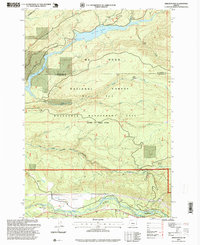
1997 Map of Brightwood
USGS Topo · Published 1999About this map
Brightwood and the smaller settlements of Marmot and Alder Creek anchor the southern portion of this landscape, where the Salmon River and Sandy River converge. The northern half is dominated by the Bull Run Watershed Management Unit, a restricted area containing Bull Run Reservoir No. 1 and Bull Run Reservoir No. 2. This protected zone, established to safeguard a municipal water supply, contrasts with the surrounding industrial activity evident in the numerous resource extraction sites. Numerous mining operations including Southside Quarry, Publishers Quarry, and Mound Quarry are scattered throughout the Mt Hood National Forest. Notable landmarks such as Porters Point and Hickman Butte overlook the complex drainage system of Camp Creek, Cedar Creek, and the Little Sandy River.
Find a feature on this map
45 named features on this map. Tap any name to fly to it.
Don’t see what you’re looking for? This feature index may not catch every label — zoom into the map to look around manually.
Map Details
Editions of this 1997 Brightwood Map
This is the sole edition of this map. No revisions or reprints were ever made.
Other maps of this area

1916 · Estacada
USGS Topo · 1:125,000

1924 · Mount Hood
USGS Topo · 1:125,000

1926 · Hood River
USGS Topo · 1:125,000

1927 · Mount Hood
USGS Topo · 1:125,000

1929 · Hood River
USGS Topo · 1:125,000

1948 · Vancouver
USGS Topo · 1:250,000

1950 · Vancouver
USGS Topo · 1:250,000

1950 · Vancouver
USGS Topo · 1:250,000

1953 · The Dalles
USGS Topo · 1:250,000

1954 · Bridal Veil
USGS Topo · 1:62,500