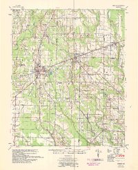
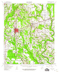
1958 Map of Brinkley
USGS Topo · Published 1959About this map
The town of Brinkley serves as the central hub for a complex network of mid-century transportation, where the St Louis Southwestern, Chicago Rock Island and Pacific, and Missouri Pacific railroads converge. This 1958 survey captures the agricultural and community structure of the eastern Arkansas Delta, characterized by significant drainage features like DeView Bayou and Big Creek. The landscape is dotted with combined community centers such as Addison Ch & Sch and New Hope Ch & Sch, reflecting the dual role of rural institutions in this era.
Find a feature on this map
63 named features on this map. Tap any name to fly to it.
Don’t see what you’re looking for? This feature index may not catch every label — zoom into the map to look around manually.
Map Details
Editions of this 1958 Brinkley Map
2 editions found
Other maps of this area

1935 · Clarendon
USGS Topo · 1:62,500

1935 · Gregory
USGS Topo · 1:62,500

1939 · Wynne
USGS Topo · 1:62,500

1939 · Hunter
USGS Topo · 1:62,500

1940 · Marvell
USGS Topo · 1:62,500

1940 · Holly Grove
USGS Topo · 1:62,500

1940 · Brinkley
USGS Topo · 1:62,500

1940 · Marianna
USGS Topo · 1:62,500

1941 · De Valls Bluff
USGS Topo · 1:62,500

1941 · Clarendon
USGS Topo · 1:62,500