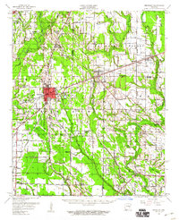
1958 Map of Brinkley
USGS Topo · Published 1960About this map
Brinkley serves as a central rail and transportation hub for the Arkansas Delta on this 1950s-era map, where the crossing of the St Louis Southwestern and Chicago Rock Island and Pacific railroads once drove local commerce. The landscape is defined by the drainage networks of De View Bayou and Cypress Bayou, which flow through a region of scattered agricultural settlements and rural community centers. Genealogists can find numerous country churches and cemeteries, such as Beauty Spot Ch & Sch and Macedonia Cem, which reflect the localized social structure of the mid-20th century.
Find a feature on this map
75 named features on this map. Tap any name to fly to it.
Don’t see what you’re looking for? This feature index may not catch every label — zoom into the map to look around manually.
Map Details
Editions of this 1958 Brinkley Map
2 editions found
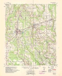
Other maps of this area

1935 · Clarendon
USGS Topo · 1:62,500

1935 · Gregory
USGS Topo · 1:62,500

1939 · Wynne
USGS Topo · 1:62,500

1939 · Hunter
USGS Topo · 1:62,500

1940 · Marvell
USGS Topo · 1:62,500

1940 · Holly Grove
USGS Topo · 1:62,500

1940 · Brinkley
USGS Topo · 1:62,500

1940 · Marianna
USGS Topo · 1:62,500

1941 · De Valls Bluff
USGS Topo · 1:62,500

1941 · Clarendon
USGS Topo · 1:62,500