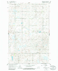
1958 Map of Brinsmade SW
USGS Topo · Published 1986About this map
Butte Valley and the surrounding townships of Albert and McClellan characterize this prairie landscape in Benson County, surveyed in the late 1950s. The map reveals a rural economy organized around section lines and local gathering places. The presence of St Olaf Ch and West Minnewaukan Ch provides specific anchors for genealogical research, marking the social centers for the scattered farmsteads of Eldon and North Viking. This topographic study, part of the Missouri River Basin development program, shows a terrain heavily pocketed with small wetlands and depressions typical of the region's glaciated geology. The inclusion of the Eldon Sch further documents the era of small, localized school districts before the widespread consolidation of rural education, while the township names like Aurora trace the civic organization of the North Dakota plains.
Find a feature on this map
12 named features on this map. Tap any name to fly to it.
Don’t see what you’re looking for? This feature index may not catch every label — zoom into the map to look around manually.
Map Details
Editions of this 1958 Brinsmade SW Map
2 editions found
Other maps of this area

1932 · Flora
USGS Topo · 1:62,500

1943 · Maddock
USGS Topo · 1:62,500

1945 · Maddock
USGS Topo · 1:62,500

1951 · Flora
USGS Topo · 1:24,000

1951 · Josephine
USGS Topo · 1:24,000

1951 · Maddock
USGS Topo · 1:24,000

1951 · Flora
USGS Topo · 1:62,500

1952 · New Rockford
USGS Topo · 1:250,000

1953 · Devils Lake
USGS Topo · 1:250,000

1956 · New Rockford
USGS Topo · 1:250,000