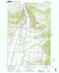
1951 Map of Brisbin
USGS Topo · Published 1981About this map
Paradise Valley serves as a vital corridor in this mid-century survey, defined by the winding course of the Yellowstone River and the high peaks of the Absaroka Range and Gallatin National Forest. The landscape shows a deep commitment to rural education and community life, anchored by a series of local institutions such as Richland Sch, Suce Creek School, Deep Creek School, and Pine Creek School. Near the settlement of Brisbin, the Paradise Valley Community Hall and Strickland Cemetery mark the social and ancestral centers for the area's ranching families. The Burlington Northern railroad parallels the river, facilitating the transport of goods through the valley. Natural landmarks like Wineglass Mountain and Canyon Mountain loom over the valley floor, while the Deep Creek Ranger Station and Luccock Park Assembly Grounds indicate the area's use for both forest management and community gatherings.
Find a feature on this map
31 named features on this map. Tap any name to fly to it.
Don’t see what you’re looking for? This feature index may not catch every label — zoom into the map to look around manually.
Map Details
Editions of this 1951 Brisbin Map
5 editions found
Other maps of this area

1891 · Livingston
USGS Topo · 1:250,000

1893 · Livingston
USGS Topo · 1:250,000

1940 · Mt. Cowen
USGS Topo · 1:62,500

1943 · Mt Cowen
USGS Topo · 1:62,500

1947 · Bozeman
USGS Topo · 1:250,000

1948 · Bozeman
USGS Topo · 1:250,000

1951 · Brisbin
USGS Topo · 1:24,000

1951 · Hoppers
USGS Topo · 1:24,000

1951 · Livingston Peak
USGS Topo · 1:24,000

1951 · Chimney Rock
USGS Topo · 1:24,000