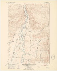
1951 Map of Brisbin
USGS Topo · Published 1953About this map
The Yellowstone River carves through this portion of Paradise Valley, where the 1950s landscape is defined by a series of irrigation ditches and small rural outposts. The Northern Pacific railroad tracks follow the river's western bank, passing through Allens Spur and the settlement of Brisbin. This era in Park County shows a distributed community supported by local institutions, including the Richland Sch and the Paradise Valley Community Hall. East of the river, the valley floor transitions into the foothills of the Gallatin National Forest, where the Deep Creek Ranger Sta and Luccock Park Assembly Grounds sit at the base of the mountains. Several schools, such as Suce Creek School and Pine Creek School, alongside the Pine Creek Ch, serve the scattered ranches like Trowbridge Ranch during this period of high-valley agricultural development.
Find a feature on this map
30 named features on this map. Tap any name to fly to it.
Don’t see what you’re looking for? This feature index may not catch every label — zoom into the map to look around manually.
Map Details
Editions of this 1951 Brisbin Map
5 editions found
Other maps of this area

1891 · Livingston
USGS Topo · 1:250,000

1893 · Livingston
USGS Topo · 1:250,000

1940 · Mt. Cowen
USGS Topo · 1:62,500

1943 · Mt Cowen
USGS Topo · 1:62,500

1947 · Bozeman
USGS Topo · 1:250,000

1948 · Bozeman
USGS Topo · 1:250,000

1951 · Brisbin
USGS Topo · 1:24,000

1951 · Hoppers
USGS Topo · 1:24,000

1951 · Livingston Peak
USGS Topo · 1:24,000

1951 · Chimney Rock
USGS Topo · 1:24,000