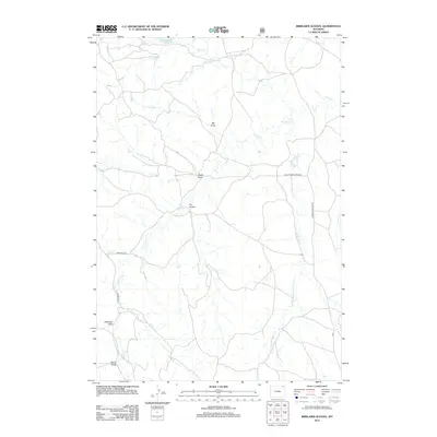
2012 Map of Brislawn School
USGS Topo · Published 2012About this map
Edgerton Reservoir and the headwaters of Horse Cr define the northern drainage of this Campbell County landscape, where the high plains are carved by an intricate network of seasonal watercourses. The map reveals a ranching and rural transport system etched into the terrain, characterized by long-distance thoroughfares like the Moorcroft-Parks Rd and Hulett-Prairie Creek Rd. These routes follow the natural contours of the land, connecting disparate points across a series of named topographic depressions such as Big Draw, Heald Draw, and Dry Hollow. The drainage pattern is particularly dense in the east along Short Prong Prairie Cr, illustrating the rugged erosional character of this portion of Wyoming. Remote access is marked by specialized routes including Deadman Rd and Bergreen Rd, which serve the isolated draws and prairie flats.
Find a feature on this map
18 named features on this map. Tap any name to fly to it.
Don’t see what you’re looking for? This feature index may not catch every label — zoom into the map to look around manually.
Map Details
Editions of this 2012 Brislawn School Map
This is the sole edition of this map. No revisions or reprints were ever made.
Other maps of this area

1905 · Devils Tower
USGS Topo · 1:125,000

1954 · Gillette
USGS Topo · 1:250,000

1955 · Gillette
USGS Topo · 1:250,000

1957 · Oshoto
USGS Topo · 1:62,500

1957 · Cedar Ridge
USGS Topo · 1:62,500

1958 · Gillette
USGS Topo · 1:250,000

1962 · Gillette
USGS Topo · 1:250,000
1972 · Bonnie Reservoir
USGS Topo · 1:24,000
1972 · Bowman Hill
USGS Topo · 1:24,000
1972 · Brislawn School
USGS Topo · 1:24,000