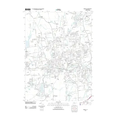
2012 Map of Bristol
USGS Topo · Published 2012About this map
The Pequabuck River carves through this industrial and residential landscape, anchoring a network of historic neighborhoods including Forestville, Federal Hill, and East Bristol. The map captures the dense infrastructure of the early 21st century, where modern developments like the Technology Park and Tunxis Community College sit alongside legacy features such as the New Haven and Northampton Canal. In the southern portion of the sheet, Compounce Lake and Compounce Mountain define the recreational and natural boundary of the area. Educational institutions like the Briarwood College for Women and local gathering spots such as the Pequabuck Golf Course illustrate the community's mid-century expansion and civic life. The landscape is dotted with ancestral sites, from West Cem to the Lamson Corner Cem in the north, providing a clear record of local settlement patterns and genealogy.
Find a feature on this map
90 named features on this map. Tap any name to fly to it.
Don’t see what you’re looking for? This feature index may not catch every label — zoom into the map to look around manually.
Map Details
Editions of this 2012 Bristol Map
This is the sole edition of this map. No revisions or reprints were ever made.
Other maps of this area

1892 · Winsted
USGS Topo · 1:62,500

1892 · Meriden
USGS Topo · 1:62,500

1892 · Granby
USGS Topo · 1:62,500

1893 · Waterbury
USGS Topo · 1:62,500

1893 · Meriden
USGS Topo · 1:62,500

1904 · Waterbury
USGS Topo · 1:62,500

1904 · Litchfield
USGS Topo · 1:125,000

1906 · Farmington
USGS Topo · 1:125,000
1946 · Meriden
USGS Topo · 1:31,680
1946 · New Britain
USGS Topo · 1:31,680