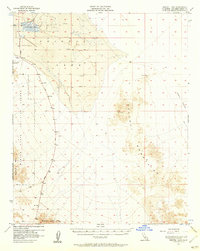
1956 Map of Bristol Lake
USGS Topo · Published 1960About this map
Bristol Lake dominates the northwestern corner of this mid-century survey, defined by its extensive Salt Evaporators and an industrial landscape of scattered prospects. The arid basin sits at the center of a rugged topographical convergence where the Calumet Mountains rise to the east and the Bullion Mts and Sheep Hole Mts frame the south and west. This 1950s record captures the region during a period of significant military and industrial utility, evidenced by the large Marine Corps Training Center boundary cutting through the western mountains.
Find a feature on this map
15 named features on this map. Tap any name to fly to it.
Don’t see what you’re looking for? This feature index may not catch every label — zoom into the map to look around manually.
Map Details
Editions of this 1956 Bristol Lake Map
2 editions found

Other maps of this area

1942 · Amboy
USGS Topo · 1:250,000

1943 · Amboy
USGS Topo · 1:250,000

1943 · Danby
USGS Topo · 1:62,500

1943 · Cadiz Lake
USGS Topo · 1:62,500

1943 · Cadiz Valley
USGS Topo · 1:62,500

1954 · Needles
USGS Topo · 1:250,000

1954 · Bristol Lake NW
USGS Topo · 1:24,000

1954 · Amboy Crater
USGS Topo · 1:24,000

1954 · Bristol Lake SW
USGS Topo · 1:24,000

1955 · Lead Mtn. NE
USGS Topo · 1:24,000