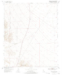
1954 Map of Bristol Lake SW
USGS Topo · Published 1975About this map
The Marine Corps Training Center dominates the western portion of this high-desert landscape, where the rugged slopes of the Bullion Mountains descend toward the Bristol Lake basin. This 1954 survey captures a specialized military landscape during the height of the Cold War, showing the stark transition from mountain peaks to the vast alluvial fans of the Mojave. Amboy Road provides the primary north-south passage through this territory, leading toward the Sheep Hole Mts in the south. The mapping of a simple Jeep Trail cutting across the desert floor underscores the importance of off-road mobility in this arid environment, which served as a critical training ground for amphibious and desert warfare tactics in the mid-20th century.
Find a feature on this map
6 named features on this map. Tap any name to fly to it.
Don’t see what you’re looking for? This feature index may not catch every label — zoom into the map to look around manually.
Map Details
Editions of this 1954 Bristol Lake SW Map
3 editions found
Other maps of this area

1942 · Amboy
USGS Topo · 1:250,000

1943 · Amboy
USGS Topo · 1:250,000

1954 · Needles
USGS Topo · 1:250,000

1954 · Bristol Lake NW
USGS Topo · 1:24,000

1954 · Bristol Lake SW
USGS Topo · 1:24,000

1955 · Lead Mtn. NE
USGS Topo · 1:24,000
1955 · Cleghorn Lakes
USGS Topo · 1:24,000

1955 · Lead Mountain
USGS Topo · 1:62,500

1956 · Needles
USGS Topo · 1:250,000

1956 · Dale Lake
USGS Topo · 1:62,500