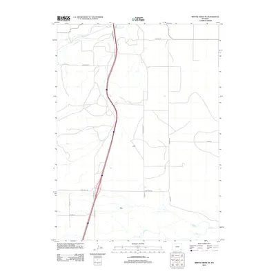
2012 Map of Bristol Ridge NE
USGS Topo · Published 2012About this map
Chugwater Cr and Dry Cr define the northern drainage of this high plains landscape in Platte County, where ranching and transportation dominate the geography. The map captures the agricultural footprint of the area through established operations like the C S Ranch and A X Ranch, connected by a network of rural routes such as Happy Hollow Rd and Blue Rock Rd. The primary north-south artery, the S Chugwater Hwy, runs parallel to the I 25 Service Rd, illustrating the modern transit corridor that cuts through traditional grazing lands. Further south, the terrain transitions toward the headwaters of Bear Cr and N Bear Cr, while isolated features like Mud Spring highlight the critical role of water sources in this semi-arid environment.
Find a feature on this map
22 named features on this map. Tap any name to fly to it.
Don’t see what you’re looking for? This feature index may not catch every label — zoom into the map to look around manually.
Map Details
Editions of this 2012 Bristol Ridge NE Map
This is the sole edition of this map. No revisions or reprints were ever made.
Other maps of this area

1953 · Double L Ranch
USGS Topo · 1:24,000

1953 · Chugwater
USGS Topo · 1:24,000

1954 · Cheyenne
USGS Topo · 1:250,000

1958 · Cheyenne
USGS Topo · 1:250,000

1962 · Moffett Ranch
USGS Topo · 1:24,000

1962 · Bristol Ridge
USGS Topo · 1:24,000

1962 · Bristol Ridge NE
USGS Topo · 1:24,000
1962 · Whitcomb Hill
USGS Topo · 1:24,000

1963 · C S Ranch
USGS Topo · 1:24,000

1963 · Klutz Canyon
USGS Topo · 1:24,000