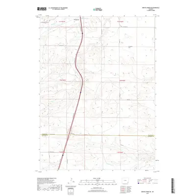
2017 Map of Bristol Ridge NE
USGS Topo · Published 2017About this map
Chugwater serves as the primary hub of this high-plains landscape, where the northern drainage of Chugwater Cr meets the extensive plateau of the Chugwater Flats. The map reveals a transition between the county lines of Platte Co and Laramie Co, characterized by a network of ranch and service roads like Iron Mountain Rd and Blue Rock Rd. The southern portion of the sheet is defined by the winding paths of N Bear Cr and Bear Cr near the secluded Mud Spring, highlighting the critical importance of water sources in this dry environment. Tracing the S Chugwater Hwy, one can observe how modern transportation corridors follow the natural contours of the drainage basins, connecting the scattered homesteads and pastures that define the rural character of this region.
Find a feature on this map
29 named features on this map. Tap any name to fly to it.
Don’t see what you’re looking for? This feature index may not catch every label — zoom into the map to look around manually.
Map Details
Editions of this 2017 Bristol Ridge NE Map
This is the sole edition of this map. No revisions or reprints were ever made.
Other maps of this area

1953 · Double L Ranch
USGS Topo · 1:24,000

1953 · Chugwater
USGS Topo · 1:24,000

1954 · Cheyenne
USGS Topo · 1:250,000

1958 · Cheyenne
USGS Topo · 1:250,000

1962 · Moffett Ranch
USGS Topo · 1:24,000

1962 · Bristol Ridge
USGS Topo · 1:24,000

1962 · Bristol Ridge NE
USGS Topo · 1:24,000
1962 · Whitcomb Hill
USGS Topo · 1:24,000

1963 · C S Ranch
USGS Topo · 1:24,000

1963 · Klutz Canyon
USGS Topo · 1:24,000