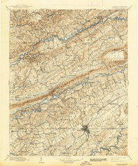
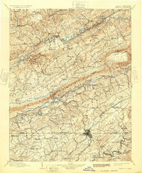
1902 Map of Bristol
USGS Topo · Published 1939About this map
Bristol serves as the hub of this Central Appalachian landscape, where the Virginia Tennessee boundary line splits the growing city. The late nineteenth-century topography is defined by the massive parallel ridges of Clinch Mountain, Copper Ridge, and Kent Ridge, which channel the Clinch River and the South Fork Holston River through narrow valleys. The map documents an era of river-dependent industry and early rail expansion, featuring numerous water-level crossings like Nash Ford and Hilton Ford alongside the emerging networks of the Norfolk and Western RR and the Southern RR. Small agrarian and milling outposts such as Hancheus Mill, Maces Spring, and Dungannon are scattered throughout the hollows. The presence of the Jefferson National Forest in the north indicates the significant timber and mountain resources that shaped the local economy before the onset of modern industrialization.
Find a feature on this map
127 named features on this map. Tap any name to fly to it.
Don’t see what you’re looking for? This feature index may not catch every label — zoom into the map to look around manually.
Map Details
Editions of this 1902 Bristol Map
6 editions found

Other maps of this area

1886 · Grundy
USGS Topo · 1:125,000

1890 · Whitesburg
USGS Topo · 1:125,000

1890 · Grundy
USGS Topo · 1:125,000

1891 · Tazewell
USGS Topo · 1:125,000

1891 · Roan Mountain
USGS Topo · 1:125,000

1891 · Abingdon
USGS Topo · 1:125,000

1892 · Grundy
USGS Topo · 1:125,000

1892 · Greeneville
USGS Topo · 1:125,000

1892 · Whitesburg
USGS Topo · 1:125,000

1893 · Cranberry
USGS Topo · 1:125,000