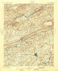
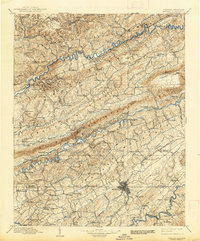
1902 Map of Bristol
USGS Topo · Published 1932About this map
Bristol stands as the central hub of this turn-of-the-century landscape, straddling the Virginia Tennessee state line and serving as a critical junction for the Southern RR and other vital rail routes. The topography is dominated by the parallel ridges of Clinch Mountain and Copper Ridge, which channel the Clinch River and the forks of the Holston River through narrow, fertile valleys. The map documents a predominantly agrarian economy dependent on local water power, evidenced by a string of family-named mills such as Bickley Mill, Hawkins Mill, and Jessees Mills positioned along the various creeks and runs.
Find a feature on this map
161 named features on this map. Tap any name to fly to it.
Don’t see what you’re looking for? This feature index may not catch every label — zoom into the map to look around manually.
Map Details
Editions of this 1902 Bristol Map
6 editions found

Other maps of this area

1886 · Grundy
USGS Topo · 1:125,000

1890 · Whitesburg
USGS Topo · 1:125,000

1890 · Grundy
USGS Topo · 1:125,000

1891 · Tazewell
USGS Topo · 1:125,000

1891 · Roan Mountain
USGS Topo · 1:125,000

1891 · Abingdon
USGS Topo · 1:125,000

1892 · Grundy
USGS Topo · 1:125,000

1892 · Greeneville
USGS Topo · 1:125,000

1892 · Whitesburg
USGS Topo · 1:125,000

1893 · Cranberry
USGS Topo · 1:125,000