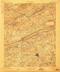
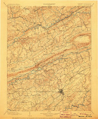
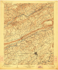
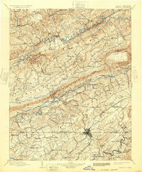
1902 Map of Bristol
USGS Topo · Published 1912About this map
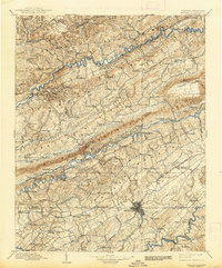
Clinch Mountain and Walker Mountain dominate the topography of this Appalachian borderland, where the Clinch River and North Fork Holston River carve through the deep ridges of Southwest Virginia and Upper East Tennessee. The landscape is defined by the early industrial development of the coalfields near Coeburn and Banner, as well as the strategic placement of river crossings like Childress Ferry. The settlement pattern reflects a transition from river-based commerce to railroad expansion, with the Norfolk and Western RR and South Atlantic and Ohio RR threading through the gaps to connect isolated valley communities.
Find a feature on this map
155 named features on this map. Tap any name to fly to it.
Don’t see what you’re looking for? This feature index may not catch every label — zoom into the map to look around manually.
Map Details
Editions of this 1902 Bristol Map
6 editions found

Other maps of this area

1886 · Grundy
USGS Topo · 1:125,000

1890 · Whitesburg
USGS Topo · 1:125,000

1890 · Grundy
USGS Topo · 1:125,000

1891 · Tazewell
USGS Topo · 1:125,000

1891 · Roan Mountain
USGS Topo · 1:125,000

1891 · Abingdon
USGS Topo · 1:125,000

1892 · Grundy
USGS Topo · 1:125,000

1892 · Greeneville
USGS Topo · 1:125,000

1892 · Whitesburg
USGS Topo · 1:125,000

1893 · Cranberry
USGS Topo · 1:125,000