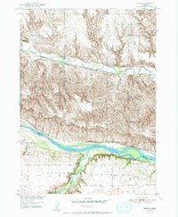
1951 Map of Bristow
USGS Topo · Published 1951About this map
The Niobrara River defines the southern reach of this Nebraska landscape, marking the boundary between Boyd and Holt counties. This mid-century survey reveals a rural infrastructure reliant on the Chicago and North Western railroad line, which tracks alongside Ponca Creek through the heart of the Bristow and Lynch districts. The map documents a dense network of country schoolhouses, such as School No 57 and School No 13, which were once the social anchors for farming families in townships like Morton and Mullen. While the village of Bristow serves as a central hub, the surrounding terrain is dotted with functional landmarks like the Mission Cem and various windmills. Notably, the map records School No 84 (Abandoned), capturing a moment of consolidation as the rural school system began to shift.
Find a feature on this map
23 named features on this map. Tap any name to fly to it.
Don’t see what you’re looking for? This feature index may not catch every label — zoom into the map to look around manually.
Map Details
Editions of this 1951 Bristow Map
3 editions found
Other maps of this area

1950 · Dorsey NW
USGS Topo · 1:24,000

1950 · Lynch
USGS Topo · 1:24,000

1951 · Bristow
USGS Topo · 1:24,000

1952 · Spencer South
USGS Topo · 1:24,000

1954 · Meek NE
USGS Topo · 1:24,000

1954 · Meek
USGS Topo · 1:24,000

1955 · O'Neill
USGS Topo · 1:250,000

1959 · O'Neill
USGS Topo · 1:250,000

1964 · Gross
USGS Topo · 1:24,000
1964 · Spencer North
USGS Topo · 1:24,000