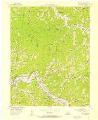
1954 Map of Broad Bottom
USGS Topo · Published 1955About this map
The Levisa Fork valley in eastern Kentucky serves as the primary corridor for settlement and industry in the mid-1950s, where the Chesapeake and Ohio railroad tracks parallel the winding river. Small communities such as Blair Town, Mossy Bottom, and Broad Bottom are tightly packed along the narrow valley floors, while the surrounding hills are dotted with hundreds of Gas Wells, indicating the region's intensive natural gas extraction. The presence of numerous specialized institutions like the Academy Sch, Mullins Sch, and the Pikeville Airfield suggests a transition from rural homesteading toward a more organized industrial and educational landscape. Local social life is evidenced by the Snivley Chapel, a Golf Course, and a Drive-in Theater near Boldman, showing how entertainment and community hubs followed the main transportation arteries between the ridges.
Find a feature on this map
54 named features on this map. Tap any name to fly to it.
Don’t see what you’re looking for? This feature index may not catch every label — zoom into the map to look around manually.
Map Details
Editions of this 1954 Broad Bottom Map
This is the sole edition of this map. No revisions or reprints were ever made.
Other maps of this area

1886 · Prestonsburg
USGS Topo · 1:125,000

1886 · Grundy
USGS Topo · 1:125,000

1887 · Warfield
USGS Topo · 1:125,000

1890 · Whitesburg
USGS Topo · 1:125,000

1890 · Grundy
USGS Topo · 1:125,000

1891 · Warfield
USGS Topo · 1:125,000

1892 · Grundy
USGS Topo · 1:125,000

1892 · Whitesburg
USGS Topo · 1:125,000

1892 · Prestonsburg
USGS Topo · 1:125,000

1914 · Laynesville
USGS Topo · 1:48,000