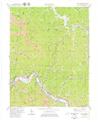
1979 Map of Broad Bottom
USGS Topo · Published 1979About this map
The Levisa Fork carves a deep path through the coal-rich hills of eastern Kentucky, anchoring a chain of valley settlements along its banks. This late-1970s landscape shows the industrial density of the region, where the Chesapeake and Ohio railroad tracks follow the river's curve past Blair Town and Broad Bottom. The map reveals a transition in land use, from traditional small-scale farming at May Farm to the intensive footprints of modern infrastructure, including the Coal Run Substation and the Pikeville Airport.
Find a feature on this map
72 named features on this map. Tap any name to fly to it.
Don’t see what you’re looking for? This feature index may not catch every label — zoom into the map to look around manually.
Map Details
Editions of this 1979 Broad Bottom Map
This is the sole edition of this map. No revisions or reprints were ever made.
Other maps of this area

1886 · Prestonsburg
USGS Topo · 1:125,000

1886 · Grundy
USGS Topo · 1:125,000

1887 · Warfield
USGS Topo · 1:125,000

1890 · Whitesburg
USGS Topo · 1:125,000

1890 · Grundy
USGS Topo · 1:125,000

1891 · Warfield
USGS Topo · 1:125,000

1892 · Grundy
USGS Topo · 1:125,000

1892 · Whitesburg
USGS Topo · 1:125,000

1892 · Prestonsburg
USGS Topo · 1:125,000

1914 · Laynesville
USGS Topo · 1:48,000