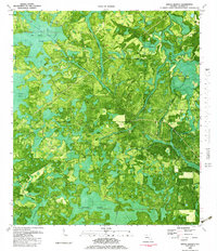
1982 Map of Broad Branch
USGS Topo · Published 1983About this map
Broad Branch and the neighboring settlement of Johntown anchor this 1980s orthophotomap of Florida's Panhandle, which highlights the region's dense hydrological network. The map reveals an intricate landscape dominated by the Wetappo Swamp and the expansive Old Camp Four Cypress Swamp. The drainage pattern is defined by the winding course of Little Cypress Creek and its many offshoots, including Bullfrog Branch.
Find a feature on this map
20 named features on this map. Tap any name to fly to it.
Don’t see what you’re looking for? This feature index may not catch every label — zoom into the map to look around manually.
Map Details
Editions of this 1982 Broad Branch Map
This is the sole edition of this map. No revisions or reprints were ever made.
Other maps of this area

1944 · Clarksville
USGS Topo · 1:31,680

1945 · Dead Lake
USGS Topo · 1:31,680

1945 · Juniper Creek
USGS Topo · 1:31,680

1945 · Youngstown
USGS Topo · 1:31,680

1945 · Clarksville
USGS Topo · 1:31,680

1945 · Broad Branch
USGS Topo · 1:31,680

1945 · North Of Allanton
USGS Topo · 1:31,680

1945 · Frink
USGS Topo · 1:31,680

1945 · Fountain
USGS Topo · 1:31,680

1945 · Tenmile Swamp
USGS Topo · 1:31,680