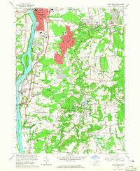
1964 Map of Broad Brook
USGS Topo · Published 1965About this map
The Connecticut River forms the western boundary of this industrial and agricultural landscape, separating Suffield and Windsor Locks from the growing towns of Thompsonville and Warehouse Point. In the mid-1960s, this area reflects a mix of traditional New England village centers and expanding suburban footprints, particularly around Enfield. The Scantic River winds through the central territory, powering historical sites like the Broad Brook Millpond and passing near the Trolley Museum.
Find a feature on this map
90 named features on this map. Tap any name to fly to it.
Don’t see what you’re looking for? This feature index may not catch every label — zoom into the map to look around manually.
Map Details
Editions of this 1964 Broad Brook Map
3 editions found
Other maps of this area

1886 · Springfield
USGS Topo · 1:62,500

1887 · Palmer
USGS Topo · 1:62,500

1889 · Springfield
USGS Topo · 1:62,500

1889 · Palmer
USGS Topo · 1:62,500

1892 · Hartford
USGS Topo · 1:62,500

1892 · Tolland
USGS Topo · 1:62,500

1893 · Springfield
USGS Topo · 1:62,500

1893 · Palmer
USGS Topo · 1:62,500

1895 · Springfield
USGS Topo · 1:62,500

1896 · Holyoke
USGS Topo · 1:125,000