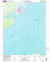
2002 Map of Broad Creek
USGS Topo · Published 2002About this map
Neuse River and Pamlico Sound dominate this coastal landscape at the start of the twenty-first century, marking the boundary between Pamlico and Carteret Counties. The intricate shoreline is defined by numerous smaller inlets and points, including Broad Creek, Swan Creek, and the family-named Pittman Creek. Small local landmarks like the Zion Hill Ch and Florence Sch near the settlement of Alice provide clear points of reference for genealogists and local historians studying these waterside communities.
Find a feature on this map
35 named features on this map. Tap any name to fly to it.
Don’t see what you’re looking for? This feature index may not catch every label — zoom into the map to look around manually.
Map Details
Editions of this 2002 Broad Creek Map
This is the sole edition of this map. No revisions or reprints were ever made.
Other maps of this area

1948 · Oriental
USGS Topo · 1:24,000

1949 · Point Of Marsh
USGS Topo · 1:24,000

1949 · Long Bay
USGS Topo · 1:24,000

1949 · Merrimon
USGS Topo · 1:24,000

1949 · South River
USGS Topo · 1:24,000

1950 · Long Bay
USGS Topo · 1:24,000

1950 · South River
USGS Topo · 1:24,000

1950 · Point Of Marsh
USGS Topo · 1:24,000

1950 · Vandemere
USGS Topo · 1:24,000

1950 · Jones Bay
USGS Topo · 1:24,000