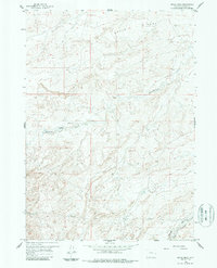
1959 Map of Broad Mesa
USGS Topo · Published 1987About this map
Broad Mesa dominates this Wyoming landscape, a high plateau defined by the erosive action of Wallace Creek and the Middle Fork Casper Creek. This mid-century topographical record shows a region shaped by high-desert ranching and early infrastructure, most notably at the 102 Ranch situated near the headwaters of the drainage. The network of unimproved dirt tracks and more established routes like Dry Creek Road and Poison Spider Rd connect the isolated ranching operations to larger arteries. A prominent Pipeline cuts across the southern sections of the map, illustrating the intersection of energy development with the traditional grazing lands. Genealogists and historians can trace the seasonal water sources such as the Spring and seasonal flows through McClanahan Draw that were vital for survival in this arid terrain.
Find a feature on this map
9 named features on this map. Tap any name to fly to it.
Don’t see what you’re looking for? This feature index may not catch every label — zoom into the map to look around manually.
Map Details
Editions of this 1959 Broad Mesa Map
3 editions found
Other maps of this area

1952 · Waltman
USGS Topo · 1:24,000

1952 · Hiland
USGS Topo · 1:24,000

1955 · Arminto
USGS Topo · 1:250,000

1955 · Casper
USGS Topo · 1:250,000

1958 · Casper
USGS Topo · 1:250,000

1958 · Arminto
USGS Topo · 1:250,000

1959 · Gaylord Reservoir
USGS Topo · 1:24,000

1959 · Eightmile Draw
USGS Topo · 1:24,000

1959 · Broad Mesa
USGS Topo · 1:24,000
1959 · Mc Rae Gap
USGS Topo · 1:24,000