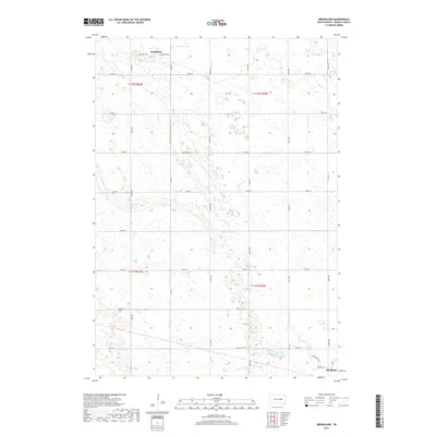
2017 Map of Broadland
USGS Topo · Published 2017About this map
Broadland anchors the northern portion of this Beadle County landscape, where the street grid of Broadview St and Broadland St transitions into an extensive network of section-line roads. The terrain is characterized by numerous prairie potholes and wetlands scattered across the plains, particularly concentrated through the central corridors. To the south, the expansion of the Huron area is evidenced by the emergence of residential developments and rural throughways such as Appaloosa Trl, Mustang St, and W Park Ave. This survey documents the intersection of modern rural development and the natural hydrology of the James River valley region, providing a clear record of land use and drainage patterns in the decade following the turn of the millennium.
Find a feature on this map
26 named features on this map. Tap any name to fly to it.
Don’t see what you’re looking for? This feature index may not catch every label — zoom into the map to look around manually.
Map Details
Editions of this 2017 Broadland Map
This is the sole edition of this map. No revisions or reprints were ever made.
Other maps of this area

1895 · Byron
USGS Topo · 1:125,000

1898 · Huron
USGS Topo · 1:125,000

1953 · Huron
USGS Topo · 1:250,000

1954 · Huron
USGS Topo · 1:250,000

1956 · Lake Byron
USGS Topo · 1:24,000

1956 · Hitchcock SE
USGS Topo · 1:24,000

1957 · Huron
USGS Topo · 1:24,000

1958 · Huron NW
USGS Topo · 1:24,000

1967 · Hitchcock SW
USGS Topo · 1:24,000
1973 · Wolsey
USGS Topo · 1:24,000