
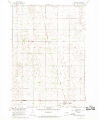
1967 Map of Hitchcock SW
USGS Topo · Published 1968About this map
Bonilla anchors the northwestern corner of this prairie landscape, where the township boundaries of Altoona, Allen, and Broadland meet. This survey, conducted as part of the Missouri River Basin development program, reveals a transition from traditional agricultural land to conservation efforts at the National Wildlife Management Area. The eastern edge of the quadrangle is defined by the Chicago and North Western rail line, which served the small communities and grain elevators of the central South Dakota plains.
Find a feature on this map
12 named features on this map. Tap any name to fly to it.
Don’t see what you’re looking for? This feature index may not catch every label — zoom into the map to look around manually.
Map Details
Editions of this 1967 Hitchcock SW Map
This is the sole edition of this map. No revisions or reprints were ever made.
Other maps of this area

1895 · Byron
USGS Topo · 1:125,000

1898 · Huron
USGS Topo · 1:125,000

1899 · Redfield
USGS Topo · 1:125,000

1950 · Wessington NE
USGS Topo · 1:24,000

1953 · Huron
USGS Topo · 1:250,000

1954 · Huron
USGS Topo · 1:250,000

1956 · Spink Colony
USGS Topo · 1:24,000

1956 · Hitchcock SE
USGS Topo · 1:24,000

1967 · Tulare SE
USGS Topo · 1:24,000
1967 · Hitchcock
USGS Topo · 1:24,000