
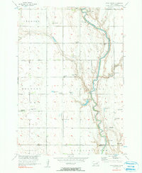
1956 Map of Spink Colony
USGS Topo · Published 1957About this map
The James River meanders through the landscape of northeastern South Dakota in the mid-1950s, anchoring a rural environment defined by small-scale townships like Cornwall, Belmont, and Lincoln. This survey, completed as part of the Department of the Interior's Missouri River Basin development program, reveals a transition in rural educational infrastructure. While the Cornwall Sch remains active, both the Lincoln Sch (Abandoned) and Saugstad Sch (Abandoned) are noted as abandoned, signaling a shift in local population patterns. Near the Hutterite settlement of Spink Colony, the river valley is punctuated by several flowing wells and the waters of Lake Dudley. Genealogists will find particular value in the location of the Hillestad Cem and the Rockwood Town Hall, which served as the civic heart for the surrounding farmsteads.
Find a feature on this map
18 named features on this map. Tap any name to fly to it.
Don’t see what you’re looking for? This feature index may not catch every label — zoom into the map to look around manually.
Map Details
Editions of this 1956 Spink Colony Map
2 editions found
Other maps of this area

1895 · Byron
USGS Topo · 1:125,000

1953 · Huron
USGS Topo · 1:250,000

1954 · Huron
USGS Topo · 1:250,000

1956 · Lake Byron NW
USGS Topo · 1:24,000

1956 · Glendale Colony
USGS Topo · 1:24,000

1956 · Lake Byron
USGS Topo · 1:24,000

1956 · Doland SW
USGS Topo · 1:24,000

1956 · Hitchcock SE
USGS Topo · 1:24,000

1967 · Frankfort SW
USGS Topo · 1:24,000

1967 · Hitchcock SW
USGS Topo · 1:24,000
Featured Places
- Cornwall Township, SD
- Spink Hutterite Colony, SD
- Lincoln Township, SD
- Crandon Township, SD
- Belmont Township, SD