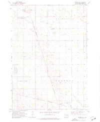
1973 Map of Broadland
USGS Topo · Published 1976About this map
Broadland serves as the primary center of activity in this Beadle County landscape during the early 1970s. The region is defined by a grid of rural townships including Broadland, Fairfield, Hartland, and Theresa, where the agricultural character of the plains is evident through features like the local Feedlot and numerous Gravel Pit operations. The Chicago and North Western railroad provides the industrial backbone for the area, running through the heart of the territory toward James Valley Junction.
Find a feature on this map
15 named features on this map. Tap any name to fly to it.
Don’t see what you’re looking for? This feature index may not catch every label — zoom into the map to look around manually.
Map Details
Editions of this 1973 Broadland Map
This is the sole edition of this map. No revisions or reprints were ever made.
Other maps of this area

1895 · Byron
USGS Topo · 1:125,000

1898 · Huron
USGS Topo · 1:125,000

1953 · Huron
USGS Topo · 1:250,000

1954 · Huron
USGS Topo · 1:250,000

1956 · Lake Byron
USGS Topo · 1:24,000

1956 · Hitchcock SE
USGS Topo · 1:24,000

1957 · Huron
USGS Topo · 1:24,000

1958 · Huron NW
USGS Topo · 1:24,000

1967 · Hitchcock SW
USGS Topo · 1:24,000
1973 · Wolsey
USGS Topo · 1:24,000