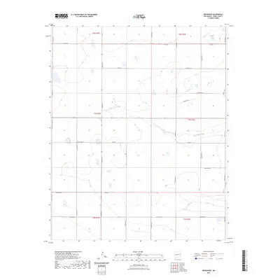
2023 Map of Broadview
USGS Topo · Published 2023About this map
Tierra Blanca Creek meanders through this high plains landscape in eastern New Mexico, providing a primary natural drainage feature in a region defined by its precise agricultural grid. The terrain is structured by an extensive network of rural routes, including Curry Road M, Curry Road F, and the centrally located Curry Rd K. This 2023 survey illustrates the modern layout of the Public Land Survey System, with township and range lines such as t7n r35e and t8n r36e organizing the territory into a patchwork of sectioned land. Significant transportation corridors like the C Ranch-To-Market-Rd facilitate movement across the plains, connecting isolated farmsteads and agricultural operations. The map documents the relationship between the ephemeral watercourse of the creek and the human-imposed geometry of county roads that sustain the local ranching economy.
Find a feature on this map
27 named features on this map. Tap any name to fly to it.
Don’t see what you’re looking for? This feature index may not catch every label — zoom into the map to look around manually.
Map Details
Editions of this 2023 Broadview Map
This is the sole edition of this map. No revisions or reprints were ever made.
Other maps of this area

1954 · Clovis
USGS Topo · 1:250,000

1957 · Pleasant Hill
USGS Topo · 1:62,500

1957 · Hammond Ranch
USGS Topo · 1:62,500

1958 · Clovis
USGS Topo · 1:250,000

1971 · Day Canyon
USGS Topo · 1:24,000

1971 · Wheatland
USGS Topo · 1:24,000

1971 · Broadview
USGS Topo · 1:24,000

1971 · Grady
USGS Topo · 1:24,000

1971 · Bellview
USGS Topo · 1:24,000
1971 · Endee Hill
USGS Topo · 1:24,000