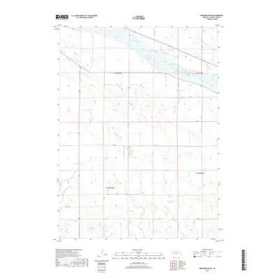
2017 Map of Broadwater SW
USGS Topo · Published 2017About this map
The North Platte River defines the northern reaches of this Morrill County landscape, where an intricate network of irrigation systems supported the region's agricultural development. Early 21st-century water management is visible through the courses of the Beerline Canal, Belmont Canal, and Browns Cr Canal, which divert water across the plains south of the river. The terrain is marked by distinctive hydrological features such as Deep Holes Spring and Camp Creek Springs, alongside numerous ephemeral drainages like Deep Holes Creek and Lower Dugout Cr. A regular grid of section lines and county roads, including RD 80 and RD 78, organizes the open country, providing clear points of reference for tracing local land use and family holdings in this rural Nebraska township.
Find a feature on this map
26 named features on this map. Tap any name to fly to it.
Don’t see what you’re looking for? This feature index may not catch every label — zoom into the map to look around manually.
Map Details
Editions of this 2017 Broadwater SW Map
This is the sole edition of this map. No revisions or reprints were ever made.
Other maps of this area

1896 · Browns Creek
USGS Topo · 1:125,000

1898 · Camp Clarke
USGS Topo · 1:125,000

1899 · Browns Creek
USGS Topo · 1:125,000

1899 · Sidney
USGS Topo · 1:125,000

1954 · Scottsbluff
USGS Topo · 1:250,000

1958 · Scottsbluff
USGS Topo · 1:250,000

1965 · Broadwater
USGS Topo · 1:24,000

1965 · Courthouse Rock
USGS Topo · 1:24,000

1965 · Broadwater NW
USGS Topo · 1:24,000
1965 · Bridgeport
USGS Topo · 1:24,000