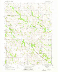
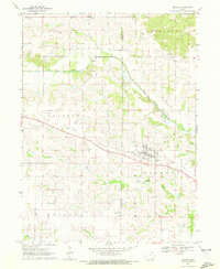
1970 Map of Brock
USGS Topo · Published 1972About this map
The North Wyaconda River and South Wyaconda River dominate this rural landscape on the border of Iowa and Missouri during the early 1970s. This borderland area, encompassing parts of Davis and Van Buren counties, is defined by its numerous small family and community burial grounds, which offer a dense record for genealogical research. Small concentrations of settlement are found at Brock, while the surrounding townships of Roscoe, Jackson, and Union remain predominantly agricultural. The drainage patterns are clearly delineated by tributaries such as Billups Branch, Cook Creek, and Willow Branch, which carve through the terrain between the two primary river forks. The presence of several distinct cemeteries, including North Bethel Cem and South Bethel Cem, suggests a long-standing pattern of dispersed rural communities anchored by local churches and family plots.
Find a feature on this map
21 named features on this map. Tap any name to fly to it.
Don’t see what you’re looking for? This feature index may not catch every label — zoom into the map to look around manually.
Map Details
Editions of this 1970 Brock Map
This is the sole edition of this map. No revisions or reprints were ever made.
Other maps of this area

1903 · Edina
USGS Topo · 1:125,000

1954 · Centerville
USGS Topo · 1:250,000

1957 · Centerville
USGS Topo · 1:250,000

1958 · Centerville
USGS Topo · 1:250,000

1965 · Memphis
USGS Topo · 1:24,000
1965 · Arbela
USGS Topo · 1:24,000

1966 · Downing
USGS Topo · 1:24,000
1970 · Cantril
USGS Topo · 1:24,000
1970 · Azen
USGS Topo · 1:24,000
1970 · Milton
USGS Topo · 1:24,000