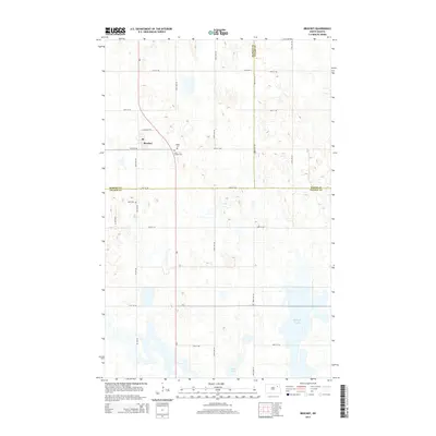
2014 Map of Brocket
USGS Topo · Published 2014About this map
Brocket serves as the primary settlement on this North Dakota prairie landscape, situated near the intersection of Nd-1 and 55th St NE. The area is characterized by a high density of small kettle ponds and wetlands typical of the region's glacial history, most notably Clear Lake and McHugh Slough. For genealogical researchers, the map provides precise locations for several local burial sites, including Saint Joseph Cem and Vaage Cem located just east of the main town site, as well as Hoff Cem further to the west. This 2014 survey documents the grid-based road network that defines the rural borders of Ramsey, Nelson, and Walsh counties, which all meet in this vicinity. The landscape is primarily shaped by agriculture and water, with a vast network of section roads like 107th Ave NE and Co Road 19 connecting isolated farmsteads across the undulating terrain.
Find a feature on this map
26 named features on this map. Tap any name to fly to it.
Don’t see what you’re looking for? This feature index may not catch every label — zoom into the map to look around manually.
Map Details
Editions of this 2014 Brocket Map
This is the sole edition of this map. No revisions or reprints were ever made.
Other maps of this area

1953 · Devils Lake
USGS Topo · 1:250,000

1956 · Devils Lake
USGS Topo · 1:250,000

1970 · Lakota
USGS Topo · 1:24,000
1970 · Bartlett
USGS Topo · 1:24,000

1971 · Michigan West
USGS Topo · 1:24,000

1971 · Brocket
USGS Topo · 1:24,000

1971 · Pelto
USGS Topo · 1:24,000

1971 · Lakota NW
USGS Topo · 1:24,000

1972 · Edmore SW
USGS Topo · 1:24,000

1972 · Adams SW
USGS Topo · 1:24,000