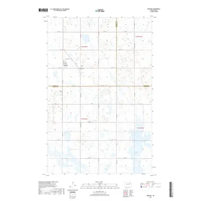
2017 Map of Brocket
USGS Topo · Published 2017About this map
Brocket serves as the primary settlement on this North Dakota prairie landscape, situated where the borders of Ramsey, Walsh, and Nelson Counties converge. The region is defined by its agricultural grid and numerous wetlands, ranging from the expansive McHugh Slough in the southeast to Clear Lake in the south-central section. For those tracing local heritage, several burial grounds are preserved across the townships, including Saint Joseph Cem and Vaage Cem located east of the main townsite, and Hoff Cem situated to the southwest. The mapping of these features, alongside a dense network of township roads like Co Rd 19 and 54th St NE, illustrates the enduring structure of this rural community in the early twenty-first century.
Find a feature on this map
23 named features on this map. Tap any name to fly to it.
Don’t see what you’re looking for? This feature index may not catch every label — zoom into the map to look around manually.
Map Details
Editions of this 2017 Brocket Map
This is the sole edition of this map. No revisions or reprints were ever made.
Other maps of this area

1953 · Devils Lake
USGS Topo · 1:250,000

1956 · Devils Lake
USGS Topo · 1:250,000

1970 · Lakota
USGS Topo · 1:24,000
1970 · Bartlett
USGS Topo · 1:24,000

1971 · Michigan West
USGS Topo · 1:24,000

1971 · Brocket
USGS Topo · 1:24,000

1971 · Pelto
USGS Topo · 1:24,000

1971 · Lakota NW
USGS Topo · 1:24,000

1972 · Edmore SW
USGS Topo · 1:24,000

1972 · Adams SW
USGS Topo · 1:24,000