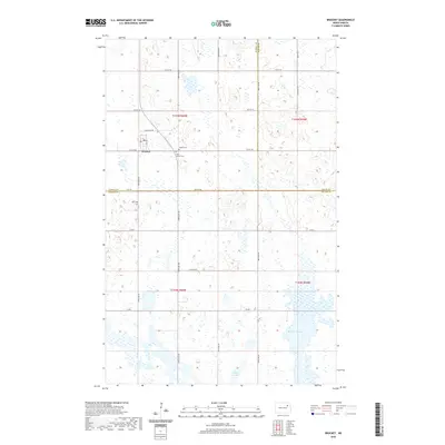
2020 Map of Brocket
USGS Topo · Published 2020About this map
Brocket sits at a geographic crossroads in Ramsey County, where the grid of sectional roads and the path of N Brocket Dr define the local grain and movement. This northern prairie landscape is characterized by its numerous small depressions and water bodies, most notably McHugh Slough and Clear Lake. For those tracing family histories in the region, the map preserves the locations of several burial grounds, including Vaage Cem, Saint Joseph Cem, and Hoff Cem, which serve as quiet markers of the area's early settlement. The map also delineates the meeting point of three counties—Ramsey, Nelson, and Walsh—providing a clear view of how these administrative lines intersect amidst the wetlands and agricultural fields of the Red River Valley's western edge.
Find a feature on this map
23 named features on this map. Tap any name to fly to it.
Don’t see what you’re looking for? This feature index may not catch every label — zoom into the map to look around manually.
Map Details
Editions of this 2020 Brocket Map
This is the sole edition of this map. No revisions or reprints were ever made.
Other maps of this area

1953 · Devils Lake
USGS Topo · 1:250,000

1956 · Devils Lake
USGS Topo · 1:250,000

1970 · Lakota
USGS Topo · 1:24,000
1970 · Bartlett
USGS Topo · 1:24,000

1971 · Michigan West
USGS Topo · 1:24,000

1971 · Brocket
USGS Topo · 1:24,000

1971 · Pelto
USGS Topo · 1:24,000

1971 · Lakota NW
USGS Topo · 1:24,000

1972 · Edmore SW
USGS Topo · 1:24,000

1972 · Adams SW
USGS Topo · 1:24,000