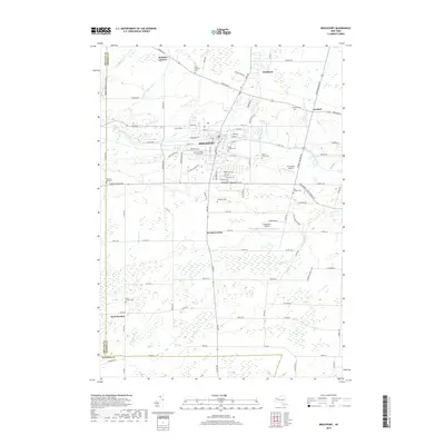
2019 Map of Brockport
USGS Topo · Published 2019About this map
The Erie Canal cuts through the heart of the village of Brockport, shaping the local geography and historical development of this Monroe County corridor. This modern survey illustrates the proximity of The College at Brockport to the historic waterway and the surrounding agricultural hamlets. To the north, the community of Clarkson lies along Ridge Road West, while small settlements like Sweden Center and West Sweden dot the southern landscape. The map's high level of detail is particularly useful for genealogists, as it identifies numerous local burial grounds including High Street Cem, Mount Olivet Cem, and East Sweden Cem. Transportation patterns are further defined by the presence of aviation facilities like the Mc Kinney Airport and Ledgedale Airpark, alongside a dense network of country roads such as Ladue Road and Beadle Road.
Find a feature on this map
104 named features on this map. Tap any name to fly to it.
Don’t see what you’re looking for? This feature index may not catch every label — zoom into the map to look around manually.
Map Details
Editions of this 2019 Brockport Map
This is the sole edition of this map. No revisions or reprints were ever made.
Other maps of this area

1897 · Albion
USGS Topo · 1:62,500

1897 · Oak Orchard
USGS Topo · 1:62,500

1899 · Hamlin
USGS Topo · 1:62,500

1899 · Brockport
USGS Topo · 1:62,500

1932 · Hamlin
USGS Topo · 1:24,000

1932 · Spencerport
USGS Topo · 1:24,000

1934 · Spencerport
USGS Topo · 1:24,000

1934 · Brockport
USGS Topo · 1:24,000
1934 · Hilton
USGS Topo · 1:24,000

1934 · Clifton
USGS Topo · 1:24,000