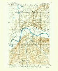
1914 Map of Brockton
USGS Topo · Published 1949About this map
The Missouri River carves a deep valley through this high-plains landscape, serving as the primary geographic anchor and the boundary between Roosevelt and Richland counties. Along its northern bank, the town of Brockton sits as a vital rail point on the Great Northern line within the Fort Peck Indian Reservation. The mapping, based on 1910–1911 surveys, reveals a transition from the river bottomlands to the prominent Mortarstone Bluff and the rising elevation of Haystack Butte.
Find a feature on this map
22 named features on this map. Tap any name to fly to it.
Don’t see what you’re looking for? This feature index may not catch every label — zoom into the map to look around manually.
Map Details
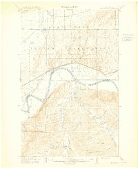
Editions of this 1914 Brockton Map
3 editions found
Other maps of this area

1909 · Glendive
USGS Topo · 1:250,000

1909 · Smoke Creek
USGS Topo · 1:62,500
1912 · Hay Creek
USGS Topo · 1:62,500

1912 · Poplar
USGS Topo · 1:62,500

1912 · Smoke Creek
USGS Topo · 1:62,500

1914 · Brockton
USGS Topo · 1:62,500

1914 · Homestead
USGS Topo · 1:62,500
1947 · Rocky Point
USGS Topo · 1:24,000

1948 · Rocky Point
USGS Topo · 1:24,000

1948 · Fort Kipp
USGS Topo · 1:24,000
Featured Places
- Brockton, Brockton District
- Brockton District, MT
- Fort Kipp District, MT
- Calais, Fort Kipp District
- Richland County, MT