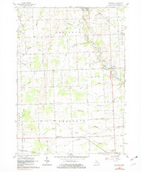
1961 Map of Brockway
USGS Topo · Published 1982About this map
Mill Creek meanders through the central landscape of St. Clair County, anchoring a rural network of small agricultural hubs and family-named landmarks in the early 1960s. The settlement of Brockway sits at the intersection of local routes, while the larger center of Yale occupies the northern reaches and Emmett marks the southern border. This terrain is characterized by an extensive system of managed watercourses like Sheehy Drain and Popplewell Drain, reflecting a long history of land reclamation for farming. Local social centers are preserved through sites like Cole Ch and the Community Gospel Chapel, alongside the Moore Cem. These features, combined with industrial remnants like a Gravel Pit, provide a clear picture of a Michigan township structured around its water drainage and local road system.
Find a feature on this map
49 named features on this map. Tap any name to fly to it.
Don’t see what you’re looking for? This feature index may not catch every label — zoom into the map to look around manually.
Map Details
Editions of this 1961 Brockway Map
2 editions found
Other maps of this area

1914 · Armada
USGS Topo · 1:62,500

1928 · Armada
USGS Topo · 1:62,500

1928 · Hicky
USGS Topo · 1:62,500

1939 · Goodells
USGS Topo · 1:24,000

1944 · Memphis
USGS Topo · 1:24,000

1945 · Allenton
USGS Topo · 1:24,000

1952 · Allenton
USGS Topo · 1:24,000

1952 · Memphis
USGS Topo · 1:24,000
1952 · Goodells
USGS Topo · 1:24,000

1954 · Detroit
USGS Topo · 1:250,000