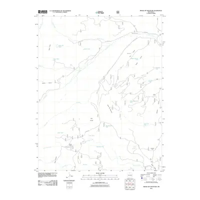
2011 Map of Broke Off Mountain
USGS Topo · Published 2011About this map
Broke Off Mountain dominates this portion of the northern New Mexico high country, marking a landscape defined by seasonal water sources and forest management routes. The map illustrates a complex network of forest roads, such as Forest Rd 80 and Forest Rd 133, which navigate the various mesas and canyons. A distinct lack of concentrated permanent settlements, save for San Antonio Cabin, suggests a region primarily used for grazing and resource management. This is supported by the density of livestock and wildlife tanks, including the Olguin Mesa Tank, Bernardo Tank, and the Game Department Tank. Hydrological patterns are clear through the courses of Rio San Antonio and Little Tusas Creek, while topographical features like Tusas Ridge and Rincon Negro provide natural barriers. Genealogists and historians may find interest in the naming of local landmarks such as Cisneros Park and Cisneros Spring, which point to family-based land use in this high-altitude environment.
Find a feature on this map
41 named features on this map. Tap any name to fly to it.
Don’t see what you’re looking for? This feature index may not catch every label — zoom into the map to look around manually.
Map Details
Editions of this 2011 Broke Off Mountain Map
This is the sole edition of this map. No revisions or reprints were ever made.
Other maps of this area

1918 · Tusas
USGS Topo · 1:125,000

1954 · Aztec
USGS Topo · 1:250,000

1955 · Cebolla
USGS Topo · 1:62,500

1955 · Brazos Peak
USGS Topo · 1:62,500

1958 · Aztec
USGS Topo · 1:250,000

1962 · Aztec
USGS Topo · 1:250,000
1963 · Los Pinos
USGS Topo · 1:24,000
1963 · Bighorn Peak
USGS Topo · 1:24,000

1963 · Broke Off Mountain
USGS Topo · 1:24,000

1963 · Burned Mountain
USGS Topo · 1:24,000