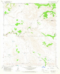
1966 Map of Bronco Gulch
USGS Topo · Published 1967About this map
San Carlos Indian Reservation land dominates this mid-1960s landscape, where the San Carlos River carves through high desert terrain. The area is defined by sharp elevation shifts between the Natanes Plateau and Warm Springs Flat, a region marked by a network of drainage systems like Kidde Canyon and Ash Creek. The scarcity of permanent settlements is reflected in the distribution of critical water resources, specifically named tanks such as Summit Tank and Red Rock Tank, which supported livestock and transit in this arid corridor.
Find a feature on this map
25 named features on this map. Tap any name to fly to it.
Don’t see what you’re looking for? This feature index may not catch every label — zoom into the map to look around manually.
Map Details
Editions of this 1966 Bronco Gulch Map
This is the sole edition of this map. No revisions or reprints were ever made.
Other maps of this area

1954 · Mesa
USGS Topo · 1:250,000

1957 · Mesa
USGS Topo · 1:250,000

1958 · Mesa
USGS Topo · 1:250,000

1960 · Mesa
USGS Topo · 1:250,000

1964 · Mesa
USGS Topo · 1:250,000

1965 · Sontag Mesa
USGS Topo · 1:24,000

1966 · Branaman Spring
USGS Topo · 1:24,000

1966 · Georges Butte
USGS Topo · 1:24,000
1966 · Ash Creek Ranch
USGS Topo · 1:24,000
1966 · Ash Creek NE
USGS Topo · 1:24,000