
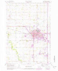
1964 Map of Brookings
USGS Topo · Published 1965About this map
South Dakota State University dominates the northeastern edge of Brookings in this mid-1960s survey, showing a hub of higher education and agriculture during a period of steady growth. The urban core is detailed with its Courthouse, regional hospital, and St Thomas Sch, while the western fringes include the Brookings Municipal Airport and a municipal Sewage Disposal plant. This map captures the city just as suburban expansion began to press against the surrounding farmlands of Sterling and Medary townships.
Find a feature on this map
36 named features on this map. Tap any name to fly to it.
Don’t see what you’re looking for? This feature index may not catch every label — zoom into the map to look around manually.
Map Details
Editions of this 1964 Brookings Map
2 editions found
Other maps of this area

1953 · Watertown
USGS Topo · 1:250,000

1958 · Watertown
USGS Topo · 1:250,000

1964 · Medary
USGS Topo · 1:24,000

1964 · Flandreau NW
USGS Topo · 1:24,000

1964 · Aurora
USGS Topo · 1:24,000

1968 · Brookings NE
USGS Topo · 1:24,000

1968 · Bruce
USGS Topo · 1:24,000

1968 · Volga
USGS Topo · 1:24,000
1968 · Rutland NW
USGS Topo · 1:24,000

1970 · White
USGS Topo · 1:24,000